It seems like a long time ago now but back in 2009 the COP21 conference in Copenhagen fixed an objective of maintaining the average global surface temperature below +2°C compared to the preindustrial era. This was reconfirmed by the Paris COP in 2015 with a more ambitious +1.5°C target.
According to the NOAA (National Oceanic and Atmospheric Administration) the world average surface temperature in 2023 was +1.18°C above the average for the 20th century and 1.48°C warmer than the 1850-1900 pre-industrial level. A record.
France has passed from an average of 11.44°C in 1900 to 13.6°C for the start of the 2020s. An increase of 2.14 °C with a noticeable acceleration since 1980. The government is forecasting +3°C for 2050 and +4°C for 2100. They may be optimistic.
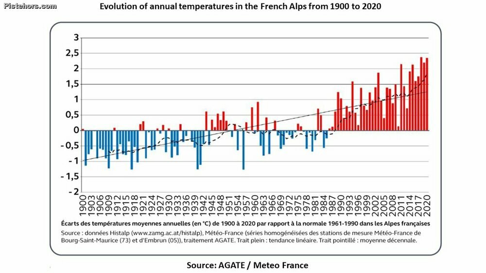
The trend in the French Alps is +2.3°C but over the last 3 years the average has been over 3°C compared to 1900. There has been a worrying uptrend in temperatures since the 2009 COP21 conference with the mountains heating at around 0.6C per decade. That is equivalent to the snowline rising 100 meters per decade with the snowline 400 meters higher on average compared to 1900.
Why is France, and more particular, the mountains warming faster than the global average?
The global surface temperature takes into account the oceans. Evaporation from the surface and mixing with colder, deeper water helps keep the sea cooler than the land, especially large continental land masses such as Europe. A further cause is the geographic position of Europe. The arctic regions are heating faster than the tropical regions for the simple reason that snow and ice reflect 70% to 87% of all energy reaching the surface. As average temperatures rise there is less snow cover and more energy is absorbed by the land creating a feedback loop. Finally warming is affecting air streams bringing warm air at both low and high altitude to Western Europe.
So far, so bad.
The problems that affect Europe as a whole also affect the Alps in greater measure. As the temperatures warm researchers have observed that plant species are climbing 30 meters per decade, and animals 100 meters. Spring comes 2 to 5 days earlier each decade.
As with the Arctic as the alpine snow cover recedes less energy is reflected into space (albedo). There is also a problem with droughts, less rainfall means drier lakes and vegetation and less evaporation which reinforces the warming. Changes in air currents are bringing more Saharan sand to Europe which again lowers the albedo of what snow there is. The mountains are also rocky and this can create a heat island. The Alps have also seen extensive construction over the last century which exacerbates the heat island effect. These individual processes act together to amplify each other perhaps even leading to a tipping point. This may be behind the more rapid heating since 2010.
With more energy in the system the weather can be more chaotic creating what the are known as whiplash weather events. For example this winter saw extensive low altitude snow in early December but then torrential rain to altitudes above 2500 which washed away the snow below 1500-1800 meters while bringing record snow cover above 2000 meters altitude.
Will next winter be as bad?
There is clearly a long term warming trend which, if it continues, will mean the average snowline by 2050 will be 250 meters higher than today, putting all low and many mid mountain ski areas in difficulty.
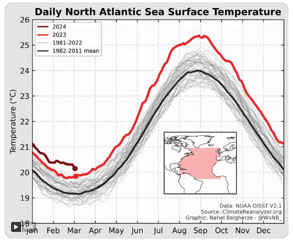
Overlaid on this trend are short term events such as El Nino in the Pacific. On 5 March the average temperature of the North Atlantic Ocean was 20.1°C as opposed to 19.9°C at the same date last year and 1°C above the 1982-2011 average. In fact the surface temperatures were above average for the whole of 2023. The North Atlantic is influenced by warming of the Arctic region as well as the reduction of pollution caused by shipping. There is less sulfur in the fuel which reflects sunlight.
In the battle between warm tropical air and cold arctic air that typically rages over Southern Europe during the winter for the last couple of seasons the warm tropical air has won more often than not. Temperatures have frequently been 3°C above average. In terms of the snow line that is 500+ meters. So whereas snow would usually lie around 1000-1200 meters for most of the winter that has been 1500 to 1700 meters this season. At some point temperatures should begin to return to mean, perhaps when the cooler la Nina returns later in the year?
References